119m range 0.9mm@50m accuracy 2D laser profiler Z+F Profiler 9012 with 360° FoV and max. 200 profiles/s scanning speed
Z+F 2D laser profiler 9012 is a compact design high-speed phase-based laser scanner, which is characterized by high precision, with 119 m ranging and 360 ° scanning field of view. Z + F 2D laser profiler 9012 has a point frequency of more than 1 million points/s and a scanning speed of up to 200 profiles/s. Even in the high-speed movement of the carrier, the high-precision scanning of the object can be realized.
Detailed parameters of Z+F 2D laser profiler 9012
Dimension | 320*260*340mm |
Weight | 13.5kg |
Laser class | Class 1 |
Wave length | 635nm |
Laser ranging mode | Phase based |
Minimum measurement range | 0.3m |
Maximum measurement range | 119m |
Data acquisition rate | Max. 1.01million pixel/sec |
Scan speed | Max. 200 profiles/s |
Range accuracy | 0.9mm@50m |
Angular resolution | 0.0088° |
FoV | 360° |
Panoramic camera | Laddybug/HD camera(optional) |
Panoramic resolution | 30M/75M pixels |
System accuracy | 5cm@100m |
Data storage | Built-in 128G SATA storage |
Input voltage | 24V DC |
Z+F 2D laser profiler 9012 adopts phase-based laser ranging mode. Compared with the general pulse laser scanner, its biggest advantage lies in the high accuracy of measurement. The ranging accuracy of Z+F 2D laser profiler 9012 can reach 0.9mm@50m , the system accuracy can reach 5cm@100m. With high point recognition rate and high measurement accuracy, it can meet the needs of strict high-precision measurement purposes.
2. High frequency
Thanks to the advanced industrial design of Z+F 2D laser profiler 9012, its laser emission frequency is up to 1.01 million points/s, and the scanning speed is up to 200 profiles/s. The ultra-high point frequency brings higher point cloud density, so as to better obtain rich target details.
Application fields of Z+F 2D laser profiler 9012
Z+F 2D laser profiler 9012 can be integrated with satellite positioning module, inertial navigation module, odometer, 360° panoramic camera, assembly control module and high-performance computer to form HiScan-Z high-precision vehicle mounted 3D LiDAR mobile mapping system. At present, the system is widely used in basic topographic mapping, thematic urban survey, traffic survey and design, street view, 3D digital city and so on.
1. Basic topographic survey and mapping
HiScan-Z high-precision 3D LiDAR mobile mapping system can quickly collect all geographical elements of the specified area, and the obtained high-precision data can meet the accuracy requirements of 1:500 topographic map. It can quickly carry out mapping production through the office data processing software, and can be widely used in the application fields of large-scale basic topographic map survey, urban terrain survey and update, urban high-precision DEM update and so on.
2. Urban municipal component survey
According to the requirements for rapid acquisition and application of municipal components and other elements in urban management, HiScan-Z high-precision 3D LiDAR mobile mapping system can quickly collect the 3D coordinate information of target features on both sides of the road, accurately and quickly extract and collect urban municipal, urban management components, traffic signs, outdoor advertisements and other features, and publish and apply the extracted and collected results, It can be seamlessly connected with existing digital urban management systems and can be applied to urban management application fields such as digital urban management.
3. General survey of urban landscaping
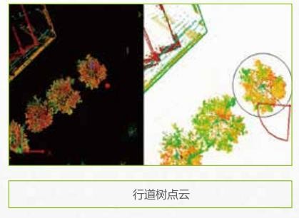
HiScan-Z high-precision 3D LiDAR mobile mapping system can quickly collect the 3Dpoint cloud data of garden trees on both sides of the road. Through the garden survey software, it can semi automatically extract the geometric information such as tree position, diameter, tree height, crown width,etc. At the same time, combined with the panoramic image, it can realize the input of tree types and other attributes.
4. Highway survey and intelligent transportation
HiScan-Z high-precision 3D LiDAR mobile mapping system collects 3D laser point clouds on the road and both sides in the process of rapid movement, and can quickly produce road vertical and horizontal sections, strip topographic maps and traffic thematic spatial geographic information data. It can be widely used in road reconstruction and expansion engineering survey, road large and medium-sized repair mapping, highway strip topographic map mapping, bridge and road as-built survey, road asset survey and database building, road 3D modeling and other application fields.
5. Digital 3D city
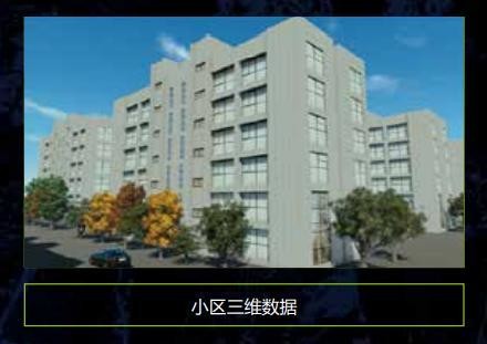
HiScan-Z high-precision 3D LiDAR mobile mapping system can quickly scan and obtain urban basic data, directly obtain 3D spatial point cloud data of the scene, corresponding high-definition texture image and panoramic image, and quickly obtain 3D data model through model data fusion technology, which can be widely used in urban geographic information sharing service, urban planning, building management, smart community, smart home and other fields.